

|
The default startup map displays 2014 aerial photography with a land base (Cadastre) overlay.
Many other base maps are available and are most easily accessed using the shortcuts tool on the toolbar. 1. Left click on the “shortcuts” tool to see a drop down listing of all of the maps which are available. 2. Choose the map which interests you to see the map data change.
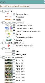
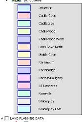
Depending upon what map you have chosen, a legend may become available from the layer listing in the left hand panel.
In the example below Suburbs has been chosen from the shortcut tool.
|

|
Left click here |
|
Manual adjustments |
|
Please note that more advanced users can re-arrange the various map layers by dragging them around within the “Layers” panel. Translucencies can also be applied by right clicking on a map layer within the “Layers” panel. |